Tamra, Jezreel Valley
<templatestyles src="Module:Hatnote/styles.css"></templatestyles>
| Tamra | |
|---|---|
| Tamra
Tamra
|
|

Tamra
|
|
| Coordinates: Lua error in package.lua at line 80: module 'strict' not found. | |
| Grid position | 188/226 PAL |
| Council | Gilboa Regional Council |
| Population (2006) | 1,300 |
| Name meaning | from to make a pit for storing corn & c.[1] |
Tamra (Arabic: طمرة; Hebrew: <templatestyles src="Script/styles_hebrew.css" />טַמְרָה or <templatestyles src="Script/styles_hebrew.css" />תַמְרָה) is an Arab village in north-eastern Israel. Located in the Jezreel Valley, it falls under the jurisdiction of Gilboa Regional Council. In 2007 it had a population of 1,300.[citation needed]
Contents
History
Archaeological excavations have found remains from the Iron Age II, the Late Persian – Early Hellenistic, Roman,[2][3] and Byzantine era.[2][3][4] A village was here in the Byzantine period; tombs and remnants of two churches have been found.[5]
Remains from the Early Islamic (Umayyad/Abbasid)[2][3][4] (including Umayyad glass vessels and Abbasid pottery and a lamp)[6] and Mamluk era have also been found.[3]
Ottoman era
During the Ottoman era, a map by Pierre Jacotin from Napoleon's invasion of 1799 noted the place, as a village.[7]
In 1875, the French explorer Victor Guérin visited Tamra and found it to be a village of about 120 inhabitants, living in adobe houses, or houses built of volcanic materials.[8] He further noted: "This village has taken the place of an ancient town which formerly rose in an amphitheatre around an abundant spring, whose waters are received in a regular basin formerly vaulted. Everywhere considerable piles of stones, for the most part basaltic; the remains of overthrown houses strew the slopes of the hill. In the midst of these confused ruins I remarked, near the spring, the vestiges of a small church lying east and west and divided into three naves. It was ornamented with columns, of which several trunks yet remain. In the higher part of the city are still distinguished the remains of a second church, almost entirely destroyed, which was paved with mosaic, as is proven by the little cubes lying about on the ground."[9]
In 1882, the Palestine Exploration Fund's Survey of Western Palestine (SWP) described Tumrah as "a village of middling size, perhaps 50 or 70 houses, situated on high ground, and surrounded by plough-land." They also noted that there were ruins on the south side of the village.[10]
British Mandate era
In the 1922 census of Palestine conducted by the British Mandate authorities, Thamra showed a population of 104, all Muslims,[11] increasing in the 1931 census to 193, still all Muslims, in a total of 34 houses.[12]
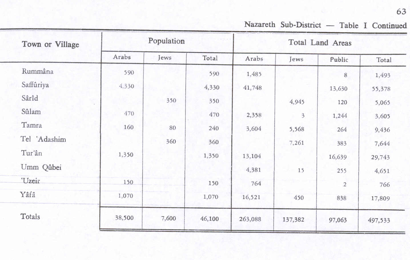
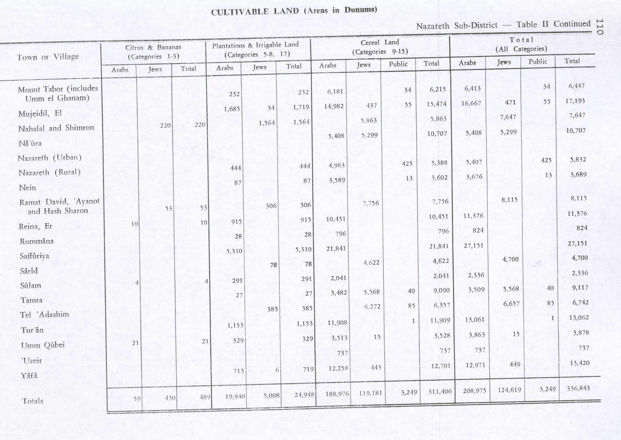
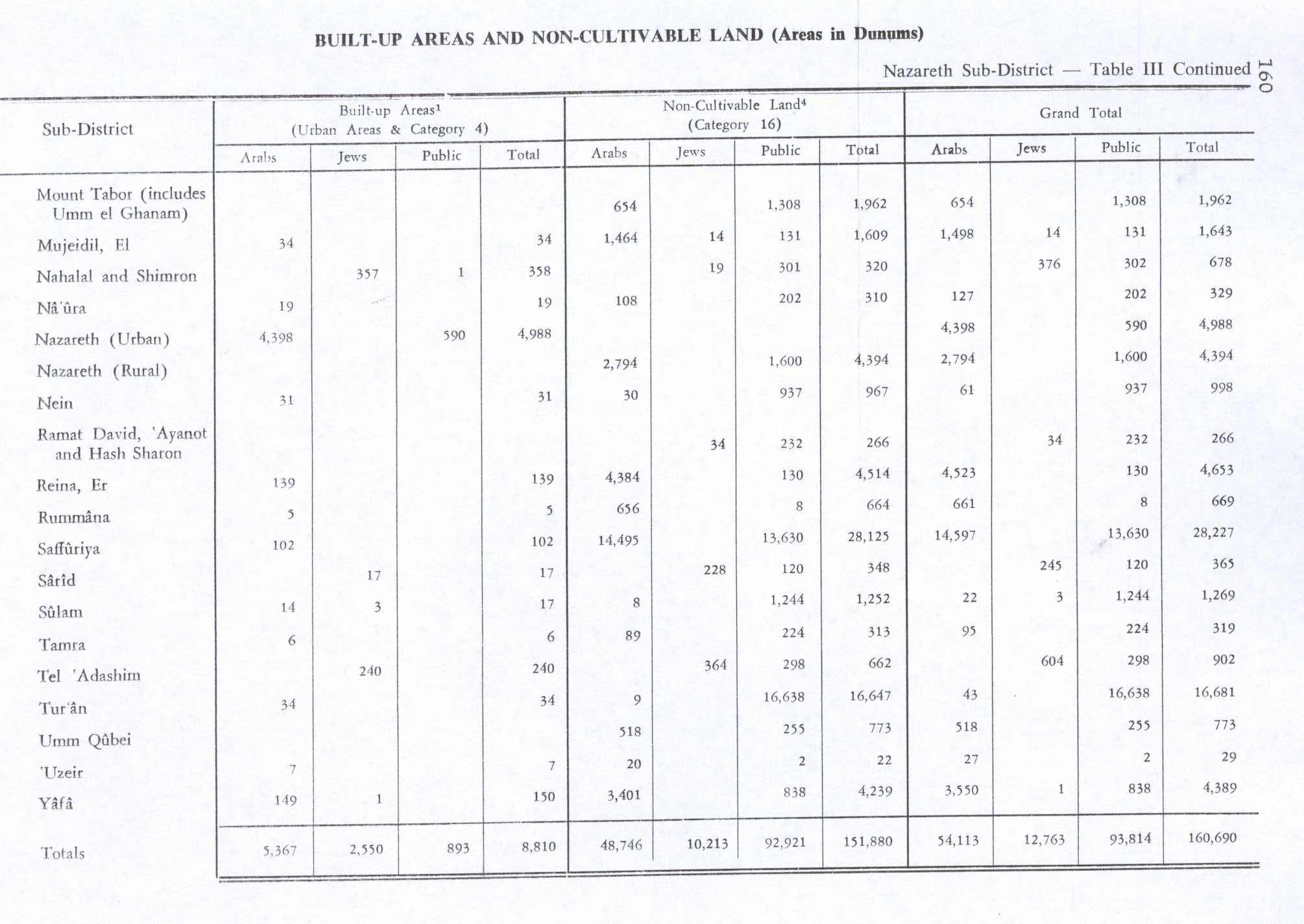
By 1945, Tamra had 240 inhabitants, 160 Arabs and 80 Jews, with a total of 9,436 dunams of land, according to an official land and population survey.[13] Of this, 27 dunams were plantations and irrigable land, 9,090 dunams were used for cereals,[14] while 6 dunams were built-up land.[15]
1948, and aftermath
After 1948, Tamra has been under Israeli rule.
See also
References
- ↑ Palmer, 1881, p. 170, see p. 117
- ↑ 2.0 2.1 2.2 Porat, 2005, Tamra
- ↑ 3.0 3.1 3.2 3.3 Tepper, 2007, Tamra Final Report
- ↑ 4.0 4.1 Abu Fana, 2009, Tamra Final Report
- ↑ Lua error in package.lua at line 80: module 'strict' not found.
- ↑ Porat, 2007, Tamra
- ↑ Karmon, 1960, p. 167.
- ↑ Guérin, 1880, p. 124
- ↑ Guérin, 1880, pp. 124-125, as translated by Conder and Kitchener, 1882, SWP II, p. 130
- ↑ Conder and Kitchener, 1882, SWP II, pp. 87- 88
- ↑ Barron, 1923, Table XI, Sub-district of Nazareth, p. 38
- ↑ Mills, 1932, p. 76
- ↑ Government of Palestine, Department of Statistics. Village Statistics, April, 1945. Quoted in Hadawi, 1970, p. 63
- ↑ Government of Palestine, Department of Statistics. Village Statistics, April, 1945. Quoted in Hadawi, 1970, p. 110
- ↑ Government of Palestine, Department of Statistics. Village Statistics, April, 1945. Quoted in Hadawi, 1970, p. 160
Bibliography
| Wikimedia Commons has media related to Tamra, Jezreel Valley. |
- Lua error in package.lua at line 80: module 'strict' not found.
- Lua error in package.lua at line 80: module 'strict' not found.
- Lua error in package.lua at line 80: module 'strict' not found.
- Lua error in package.lua at line 80: module 'strict' not found.
- Lua error in package.lua at line 80: module 'strict' not found. (p. 734)
- Lua error in package.lua at line 80: module 'strict' not found.
- Lua error in package.lua at line 80: module 'strict' not found.
- Lua error in package.lua at line 80: module 'strict' not found.
- Lua error in package.lua at line 80: module 'strict' not found.
- Lua error in package.lua at line 80: module 'strict' not found.
- Lua error in package.lua at line 80: module 'strict' not found.
- Lua error in package.lua at line 80: module 'strict' not found.
- Lua error in package.lua at line 80: module 'strict' not found.
External links
- Welcome To Tamra
- Survey of Western Palestine, Map 9: IAA, Wikimedia commons
- Pages with broken file links
- Articles containing Arabic-language text
- Articles containing Hebrew-language text
- Articles with unsourced statements from April 2010
- Commons category link is defined as the pagename
- Gilboa Regional Council
- Arab villages in Israel
- Populated places established in 1918
- Populated places in Northern District (Israel)